https://s.click.aliexpress.com/e/_oBVmL7Q
아날로그 나침반 기반의 독도법 교범이 수정되었는가?
그리고
디지털기반의 전장지도나 화력통제시스템도 반영이 되었는가?
지구의 지자기장이 수직인 지점인 북극 자기극은 수세기 동안 꾸준히 이동해 왔습니다.
1640년부터 2020년까지의 이동에 대한 역사적 지도는 최근 수세기 동안 주로 시베리아 방향으로 점진적으로 북서쪽을 향하는 궤적을 보여줍니다.
이 이동은 지난 세기에 상당히 가속화되어 극이 러시아에 빠르게 접근하고 있습니다.
이 이동은 지구의 자기장을 생성하는 지구의 용융 철심 역학의 변화에 영향을 받습니다. 고정된 지리적 극과 달리 북극 자기극의 위치는 지자기 변화로 인해 타원형 궤적 내에서 매일 변동합니다.
과학자들은 이러한 지도를 만들기 위해 수세기 동안 다양한 위치에서 수행한 자기 측정의 역사적 데이터를 사용합니다. 여기에는 오래된 나침반 판독, 화산암 샘플 및 최근 위성 관측 기록이 포함됩니다.
이미지: Nature
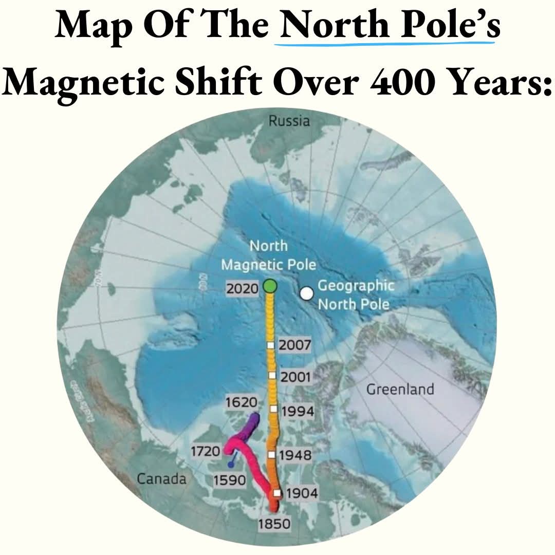
The North Magnetic Pole, the point where Earth's geomagnetic field is vertical, has been steadily shifting for centuries.
A historical mapping of its movement from 1640 to 2020 reveals a gradual northwest trajectory in more recent centuries, primarily toward Siberia.
This shift has significantly accelerated in the past century, with the pole rapidly approaching Russia.
The movement is influenced by changes in the dynamics of Earth's molten iron core, which generates the planet's magnetic field. Unlike fixed geographical poles, the North Magnetic Pole's position fluctuates daily within an oval-shaped locus due to geomagnetic variations.
To create maps like these, scientists use historical data from magnetic measurements taken at various locations over centuries, including records from old compass readings, volcanic rock samples, and recent satellite observations.
Image: Nature
'공부하기 > military. warfare.' 카테고리의 다른 글
| 가오리 닮은 ‘36011’ ◆중국 6세대 전투기 (0) | 2025.01.18 |
|---|---|
| 최초의 해외파병 베트남전! '월남특수' 약 10억 달러를 '여기'에 썼다?! (KBS 20130525 방송) (0) | 2025.01.17 |
| 동해에 뜬 러시아 핵잠! ◆야센급 핵잠 기술 혹시 북한에? (0) | 2025.01.08 |
| 코브라 헬기...보병학교에서 화력시범 참가때... (0) | 2025.01.03 |
| 한국군은 왜 연식이 70년 넘은 M48전차를 씁니까? (0) | 2025.01.02 |


댓글